Providing the Solution for the Decline of Seoul’s Old Downtown
Hanyang University School of Architectural Engineering students' ''Solution to Seoul's Old Downtown Decline Using the GIS-MCDA Method' paper was published on February 9 in "Sustainability", a SCI-level journal.
Students Chae Ji-sung (School of Architectural Engineering, Class of '17) and Oh Jung-hoon (School of Architectural Engineering, Class of '18) used the Geographic Information System (GIS) data to identify the decline of Seoul's old downtown area. They also suggested some solutions to solve the size reduction of the old downtown areas and inequality problems by providing local public services.
In the paper, the research team focused on the inequality situation in the city along with the declining old downtown areas caused by the decreasing population. Due to industrialization and urbanization, new areas are being developed inside the city, which caused the movement of population and to the downtown area's economy falling and the environment degrading. Furthermore, the aging population and low birth rate has accelerated the polarization between the new and old downtowns. As a result, the residents of the old downtown area do not have enough access to life infrastructures or public services, which is a phenomenon happening globally.
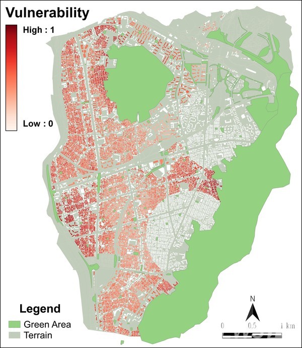
To identify the situation, the research team collected data of Seoul Jungang-gu region such as building locations, age, and usage by using the GIS-MCDA method to track down and categorize old residential areas with low accessibility to public services. (GIS-MCDA: MCDA method using GIS.MCDA (Multi Criteria Decision Analysis) is a method to find the best solution using the non-dominated solution set when the decision-making process is not easy due to conflicting standards to consider when trying to find the best solution to a problem. The non-dominated solution refers to the solution that is not dominated by any other solution.) Furthermore, they suggested an environment improvement plan for the region with "Public service provisions for the best locations using GIS" in areas identified as susceptible. Specifically, they used the "Transit-Oriented Development(TOD)" concept, selecting the location of the public service near the public transportation systems, for city-planning method to resolve the downtown declining phenomenon due to the population decrease. Through the concept, not only the land can be used efficiently due to the condensation of urban functions but also automobile transit decreases, which aims at the energy reduction and air quality refinement effect.
Regarding this, Chae Ji-sung, who lead the research paper, said, “I had the research opportunity through Hanyang University's project-centered courses and could yield meaningful results by developing it together with the research team and submitting to the international academic journal.”
Meanwhile, their research paper (Title: Urban Public Service Analysis by GIS-MCDA for Sustainable Redevelopment: A Case Study of a Megacity in Korea) was published in the SCI-level journal "Sustainability" after evaluation as to its contribution to the development of sustainable and lively cities through solving inequality problems of public services due to declining downtown areas worldwide.